White Christmas: Updated snow forecast for tonight into Wednesday
White Christmas: Updated snow forecast for tonight into Wednesday ===
Several inches of snow are likely tonight, ensuring a white Christmas for most of Maine.
![]()
 ===
===
To stream NCM on your phone, you need the NCM app.
Download the NCM app
![]()
![]()
More Videos
Next up in 5
Example video title will go here for this video
Next up in 5
Example video title will go here for this video
Author: Todd Gutner (NEWS CENTER Maine), Ryan Breton
Published: 7:52 AM EST December 22, 2025
Updated: 6:43 PM EST December 23, 2025
![]()
PORTLAND, Maine — It was looking bleak for a white Christmas when rain and warmth erased all our snow late last week, but a clipper system moving in will save the day.
Clippers are fast movers and usually don't have much moisture to work with, typically only dropping a few inches of snow. But occasionally a trough can hang back after it passes, prolonging the snow and enhancing snowfall rates, beefing up amounts in a few spots. These troughs are tough to pin down and can be fickle, but one is expected to form tonight, with central Maine and the Midcoast favored.
RELATED: How common is a white Christmas in Maine? Let's look at the data
Snow spreads east through the evening and starts to pick up in intensity, falling moderately at times in southern and central Maine. It will be a wetter snow near the coast, drier and a bit fluffier farther inland.

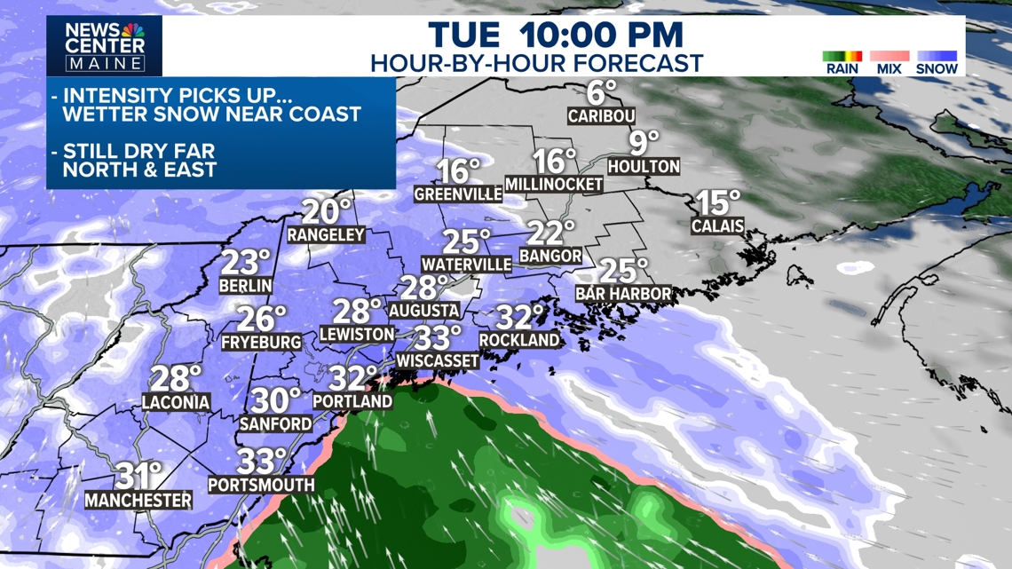
Credit: NCM
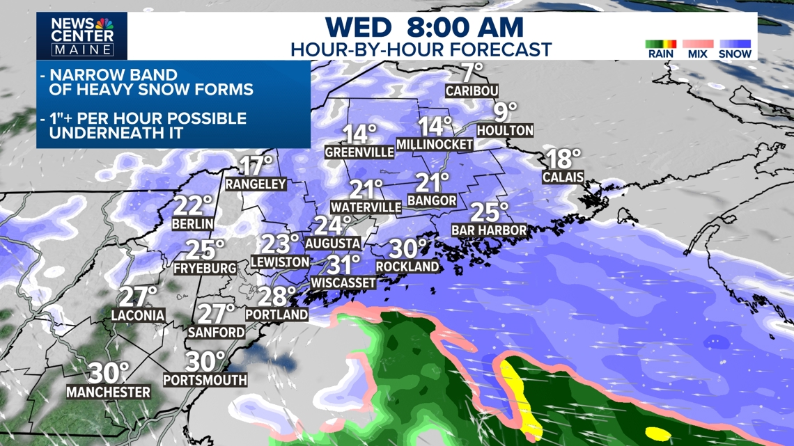
The inverted trough will likely set-up somewhere along the coast late in the night, with a band of heavier snow underneath it. Temperatures will drop a bit and the flake size will get larger; snow accumulation will become pretty efficient enhancing snow amounts in a few areas. Central Maine and the Midcoast seem favored, but this heavier snow could back into the Portland area too late tonight.

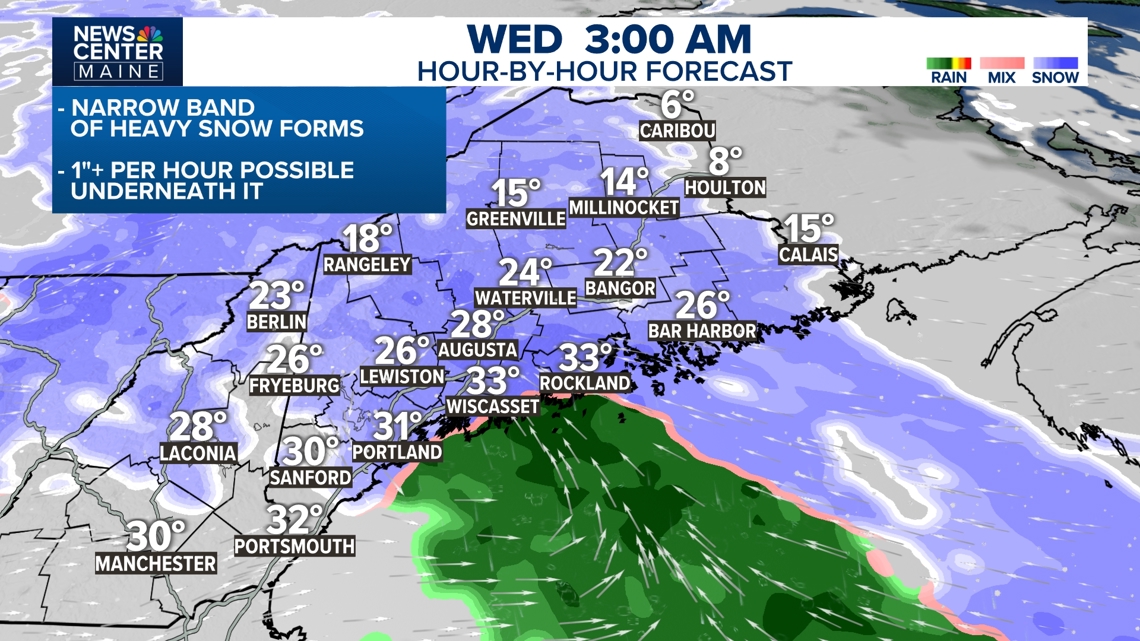
Credit: NCM
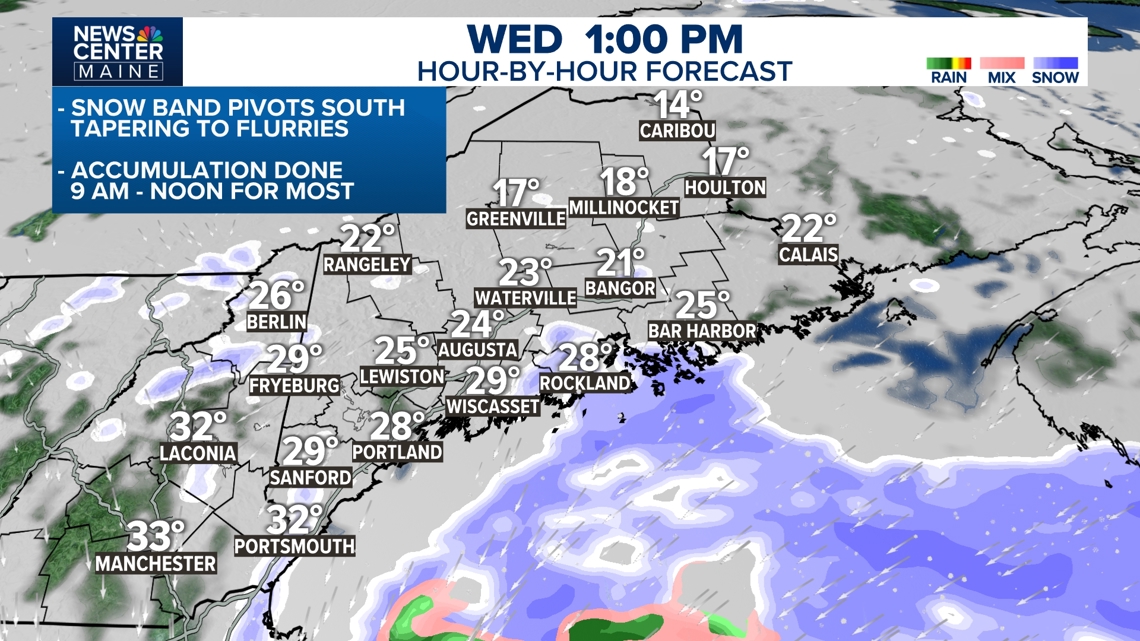
Heavy snow may continue in localized areas past sunrise. This band of snow should begin pivoting south after 8 a.m., taking the heaviest snow south with it.

Credit: NCM
The storm and trough will slide away late Christmas Eve morning and flakes will gradually taper off. In most areas the accumulation ends between 9 a.m. and noon. It will be cold and breezy behind the storm, so you'll need to shovel and plow what does fall.

Credit: NCM
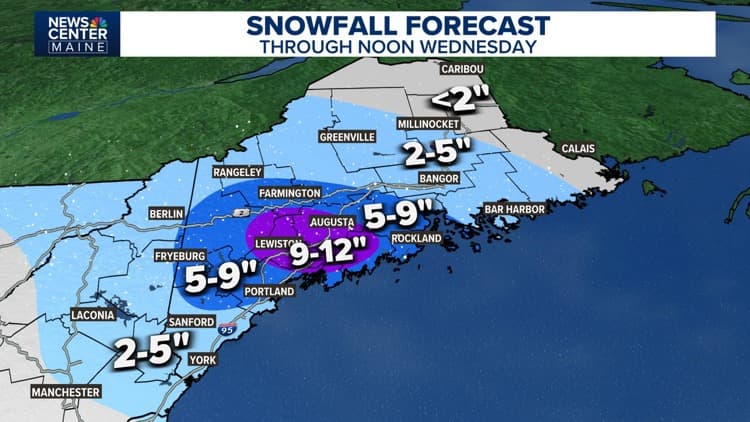
A broad area of 5" to 9" of snow is expected from Fryeburg eastward to Penobscot Bay, including Portland. Within this zone, there will likely be higher amounts up to a foot. We've highlighted that from central Maine into the Midcoast. The exact location of this bullseye will depend on where the heaviest snow bands develop in the early morning hours.
Less snow is expected from Sanford south including coastal York County, 2" to 5", and on the other side of this banding, including Bangor and Bar Harbor.


Credit: NCM
Merry Christmas...
Todd & Ryan
For more local stories continue with us on our NEWS CENTER Maine+ streaming app.
Close Ad
Source: NCM Weather
Locations: Portland, Bangor, Sanford, Bar Harbor, York
Region: Downeast